
Blur view of the New Zealand's highest mountain, Aoraki/Mount Cook in the early morning.
毛利人的神话故事: 天父和地母的孩子,在造访人间时,变成了石头,这些石头就是后来的库克山以及南阿尔卑斯山脉中一些突起的山峰, 形成了库克山的美丽奇景...

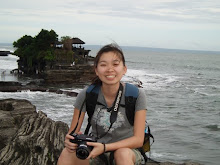
This photo I took when on my driving route to Mt Cook Village in the early morning. So excited to get closer to the Mt Cook Village...

The YHA is always fully book and very crowded all the time. During meal time, the kitchen is very crowded until you need to queue for the cooking utensil or the gas to cook because YHA is the only hostel in Mt Cook Village. Therefore, advance booking is really needed ya.
There are many short/day walks that I enjoyed in Mt Cook Village. Actually most of the tracking trails in NZ are in well maintain. It is very safe and easier to walk if compare to other country's track, especially the friendly DOC staffs. That's why I like NZ so much...
Before the tracks...
To save my time (to save budget actually :P), I did all the short walks non-stop in one day...
Day 1
YHA -> Governors Bush Walk -> Bowen Bush Walk -> Glencoe Walk -> Red Tarns Track -> Tasman Valley Walking Track -> YHA
1. Governors Bush Walk (1 hr return, 1.5 km)
This popular walk offers birdlife, a good viewpoint of the mountains and shelter in poor weather.
3. Glencoe Walk (30 min return)
Begin at the Public Shelter and follow the path to Black Birch Stream. Cross the bridge then climb steeply to the Red Tarns. A viewpoint offers a spectacular panorama of the valley and Aoraki/Mount Cook. The tarns were named from the red pond weed that grows in them.

Aoraki/Mount Cook Village as view from Red Tarn track
5. Tasman Valley Walking Track (29 km)
Blue Lakes and Tasman Glacier View (40 min return)
My walk is just start from the Blue Lakes Shelter and meander up past the lakes to a viewpoint on the moraine wall. There are good views of the lower Tasman Glacier and the mountains at the head of the valley.
I was in the real "wallpaper" ...
The Blue Lakes, originally named because of their intense blue colour, could now be more accurately described as green ponds.
Tasman Glacier Lake (1 hr)
This trip branches off the Tasman Glacier View Track just past the Blue Lakes Shelter and leads to a viewpoint of the glacier terminal lake and the source of the Tasman River.

Icebergs can be seen floating in the lake in summer, and in winter the lake freezes over.
Day 2 of my short walks...
YHA -> Hooker Valley -> Kea Point Track -> Sealy Tarns Track -> Mueller Hut -> YHA
6. Hooker Valley Track
The track passes close to the Alpine Memorial, which is a great viewpoint. Continue on to Hooker River and cross twice on swingbridges before reaching Stocking Stream Shelter. Continue beside the river to its source to reach the Hooker Glacier terminal lake.

Hooker Valley Track
7. Kea Point Walk (2 hr return, 2.8 km)
Begin as for Kea Point then branch off at the signpost to climb steeply up to the tarns. This energetic walk gives spectacular views of the Hooker Valley and the peaks of the area including Aoraki/ Mount Cook.


The Mueller Hut (3 hr return from the tarn)
No comments:
Post a Comment